Software for coordinated action

When response matters,
the stack matters.

ResponderStack is building an integrated software stack for teams solving complex, real-world problems.

Product 01

01 — 01

ImpactGrid

Map the impact.
Move the teams.
Close the gaps.

A shared operational picture for understanding need, coordinating response, and directing resources where they matter most.

Impact mapping Team coordination Gap visibility
IMPACTGRID / INCIDENT MAPIN THE FIELD
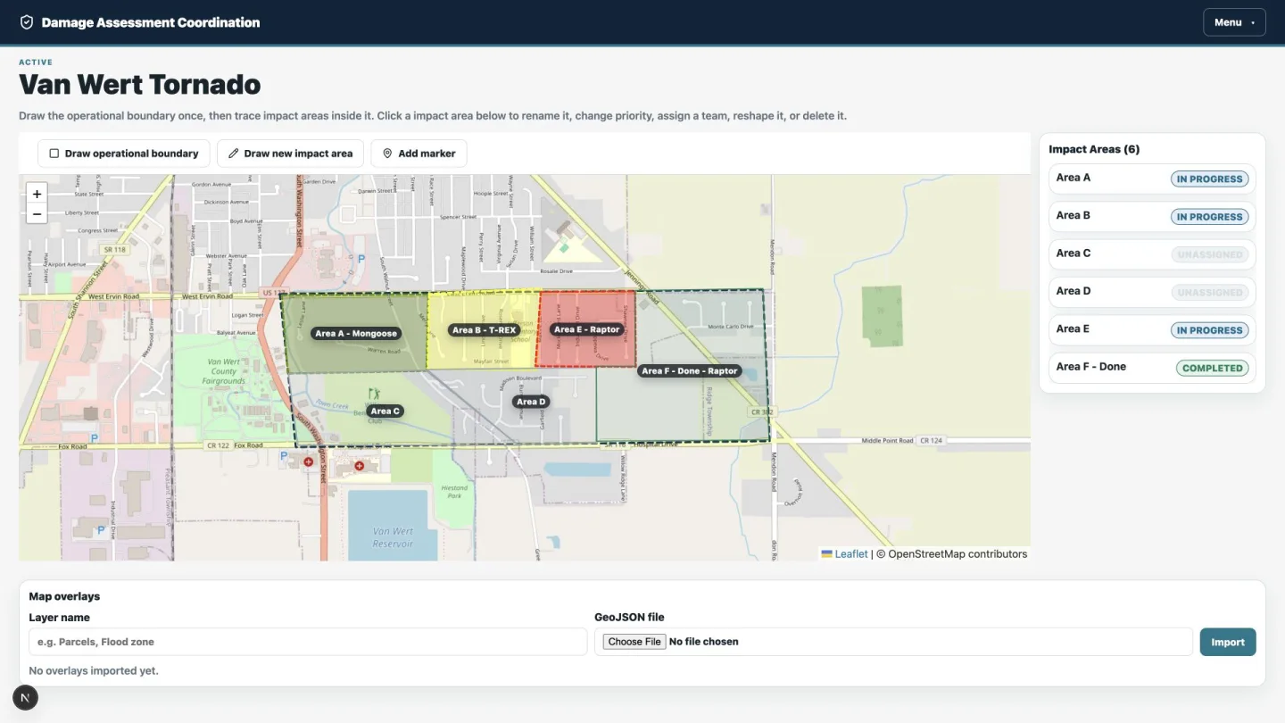
ImpactGrid incident map showing color-coded impact areas and their operational status
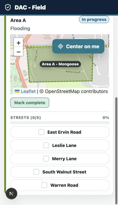
FIELD VIEW ImpactGrid mobile field view showing a team's assigned area and street checklist

Full capability set

From command post
to street level.

ImpactGrid keeps the operational picture, team movement, and field progress connected throughout an incident.

01Incident managementCreate, command, and close the operational record.
  • Create and edit incidents with names, descriptions, notes, commanders, phone numbers, and customizable area terminology.
  • Configure ICS positions, assigned names, and contact numbers.
  • Move incidents through draft, active, paused, resumed, closed, and archived states.
  • Manage multiple incidents while automatically surfacing the active incident on the dashboard.
  • Use confirmation steps to protect destructive operations.
02Live command dashboardSee progress, people, and geography in one view.
  • Monitor operational-area, mapped-area, and completed-area square mileage.
  • Track geographic completion alongside completed streets and overall street percentage.
  • See teams in the field, teams available, and every area-status count.
  • View an interactive incident map with live team-device positions and dispatch-address markers.
  • Move directly to mapping, teams, dispatch, statistics, and printing workflows.
03Operational mappingTurn the incident footprint into actionable sectors.
  • Draw and edit the operational boundary; draw, reshape, name, and delete coverage areas or sectors.
  • Search addresses, navigate the map, use full-screen mode, and center on the device location.
  • Capture area priority, notes, hazards, landmarks, access details, assignments, and field instructions.
  • Track unassigned, assigned, in-progress, completed, needs-revisit, blocked, and cancelled states—with reasons and reopening.
  • Use automatic sequential naming, team colors, permanent labels, status patterns, responsive controls, and OpenStreetMap.
04Road and street trackingMeasure coverage down to each named road.
  • Discover named roads inside mapped areas using OpenStreetMap data.
  • Generate a road checklist for each area and check streets from command or field views.
  • Calculate road mileage by area and report total, assigned, unassigned, covered, and remaining mileage.
  • Show street progress directly in map popups.
  • Preserve checklist completion when road-mileage data is refreshed.
05Markers and GIS overlaysBring operational context onto every map.
  • Add, label, annotate, and delete EOC, staging, shelter, hazard, and custom point markers.
  • Use category-specific marker icons and colors; show dispatch addresses automatically.
  • Import detailed GeoJSON layers for parcels, flood zones, hazards, and other operational data.
  • Name and color overlays, show or hide each layer on command and field maps, and delete layers when finished.
  • Support larger uploads for detailed GIS files.
06Team managementKeep field resources organized and assignable.
  • Create, edit, color-code, automatically name, and safely delete teams.
  • Record team number, leader, callsign, radio channel, vehicle, phone, members, and operational notes.
  • Track available, assigned, in-field, returning, and out-of-service states.
  • See every area assigned to a team and reassign work as conditions change.
  • Return assigned areas safely to the unassigned pool when a team is removed.
07Mobile field workflowGive each team exactly the view it needs.
  • Generate secure team-specific field links that require no user login; copy, display as QR, or regenerate them.
  • Invalidate old links after regeneration and restrict teams from changing another team’s work.
  • Show incident details, assignments, contacts with tap-to-call, dispatch addresses, and interactive maps.
  • Let teams manage overlays, start areas, complete work, and check or uncheck individual streets.
  • Display overall street completion and switch to read-only when the incident is inactive.
08Live location sharingMaintain awareness without losing device context.
  • Start and stop GPS sharing from field devices with an optional member or device name.
  • Support multiple devices per team, each with a stable unit number.
  • Show the current device and other team members on the field map with GPS accuracy.
  • Poll current positions automatically and display live team locations at command.
  • Handle stale devices, retain location samples for 24 hours, and explain permission, GPS, or network errors.
09Dispatch intakeMove requests from the queue to a field team.
  • Create address-based requests with caller, phone, street, city, state, and notes.
  • Geocode addresses automatically and verify them on the intake map.
  • Move requests through needs-review, reviewed, and assigned states.
  • Assign, reassign, unassign, edit, or delete intake records.
  • Place assigned addresses in field views, team printouts, and the command map while logging dispatch actions.
10Statistics and reportingMeasure the operation by area, road, and team.
  • Report operational, mapped, completed, remaining, assigned, and unassigned square mileage.
  • Identify operational area that has not yet been mapped.
  • Track road entries, total road mileage, and status and deployment totals.
  • Break down every area by status, team, square mileage, road count, covered roads, and remaining mileage.
11Operational printingTurn the live picture into a field-ready briefing.
  • Print incident overviews, operational maps, area rosters, assigned addresses, and deployment status.
  • Generate team rosters, contact reports, individual assignment sheets, and ICS communications rosters.
  • Produce team-specific maps, assigned-address lists, and road check-off sheets.
  • Include printed timestamps with print-aware map resizing and page styling.
12Authentication and permissionsPut the right operational controls in the right hands.
  • Use Authentik/OpenID Connect in production or optional local credentials in controlled environments.
  • Assign Administrator, Incident Commander, Operations, Team Leader, Team Member, or Viewer roles.
  • Separate incident administration, operational management, field action, and read-only permissions.
  • Protect command and administration routes while providing restricted token-based field access.
13Operational data foundationPreserve the history behind every decision.
  • Record important changes through activity logs and an audit-event model.
  • Model operational periods, assignment history, team locations, coverage tracks, and area notes.
  • Store geographic data in PostgreSQL/PostGIS with spatial indexes.
  • Use persistent Docker volumes, automated migrations, and deployment seeding.
  • Expose application health checks for container monitoring.
14Installable on every deviceUse ImpactGrid like an app, from command to field.
  • Install from a standards-based web-app manifest in standalone display mode.
  • Use branded SVG, ICO, browser, Apple home-screen, PWA, and Android-safe maskable icons.
  • Support iOS Add to Home Screen, mobile viewports, and device safe areas.
  • Show online and offline connection state.
  • Adapt navigation and layouts across desktop, tablet, and mobile screens.

The long view

02 — MISSION

One connected stack.
Every critical moment.

Critical work is too often slowed by disconnected tools and fragmented information.

ResponderStack is being built as a complete operational layer—giving teams the clarity to see what’s happening, the coordination to move together, and the confidence to act.

01ImpactGridAVAILABLE FIRST
+The stack growsMORE TO COME